The GPS Tools application is a framework of GPS dependent utilities. The application uses the onboard GPS as well as online resources to accomplish its ... Read More > or Download Now >
GPS Tools for Windows Phone
Tech Specs
- • Version: 7.9.6.3
- • Price: 0
- • Content Rating: Not Rated
- • Requirements: Windows Phone 8.1, Windows Phone 8
- • File Name: GPS-Tools.XAP
User Ratings

- • Rating Average:
- 4.6 out of 5
- • Rating Users:
- 48
Download Count
- • Total Downloads:
- 43
- • Current Version Downloads:
- 23
- • Updated: September 21, 2016
More About GPS Tools
The GPS Tools application is divided into these sub-categories:
• Location Information (Coordinates, Addresses & Elevation.
○ Select Location
○ Display Location information: Address, Coordinates, Elevation and Map
○ Share Location (Tweet, SMS, Social Networks)
○ Save as a Favorite Location
• Routes Designer
○ Define a Route
○ Edit a Route
○ Calculate a Route length
○ Display a Route Elevation Profile vs. Distance
○ Calculate a Route area
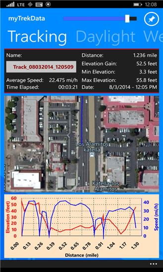
• Tracking Utilities
○ Track phone Location on a Map
○ Display elapsed Time
○ Display elapsed Distance
○ Insert Markers on a map
○ Draw tracking chart profile of Time, Distance, Elevation and Speed.
○ Display Speed
○ Display local Temperature
○ Export Tracking data to Excel
○ Save Tracking data to OneDrive
• Daylight Information
○ Select desired date
○ Calculate and display Sunrise and Sunset times
○ Display Length of Day and Solar Noon time
○ Display Twilight and Photography times
○ Calculate Sun Angle, Elevation and Azimuth
○ Display Daily Sunrise, Sunset and Length of Day chart
• Moon Information
○ Select desired Date
○ Calculate Moon-rise and Moon-set and Azimuths
○ Calculate Moon Age and Display Moon Phase
○ Calculate Full Moon and New Moon dates
• Weather Information
○ Display Current Weather conditions
○ Display five days of weather projection
○ Display five days of hourly weather conditions
• Projection and GeoFence Utilities
○ Select any two locations (use the same four location selection methods described below)
○ Calculate and draw projected point, based on distance and bearing
○ Calculate and Draw GeoFence, based on center and radius
○ Save as a Favorite Location
• Directions Utility
○ Display directions (Bing driving, walking and transit)
○ Get Directions to Favorite saved locations
○ Voice navigation interface
• Speedometer Utility
○ Display Speed
○ Display Distance
○ Display Altitude
○ Display Elapsed Time
○ Display Average Speed
○ Select Speed range: Walk, Bike, Car
• Time Zone
○ Display the Time Zone value & ID
○ Display the Daylight Saving value
○ Display a running World Clock
○ Display Hours relative to Local Time Zone
• Where Is My Car? A parking utility to mark where your Car is parking
○ Display address and coordinates for Car location
○ Share the car location
○ Display time remaining (or overrun)
○ Display walking directions to your Car
○ Take a picture of the Car location
○ Set Alarm
○ Set Toast reminder messages
• Data Utilities
○ Export data to Excel for further analysis
○ Backup data to OneDrive
○ Share data
• About & Setup
○ Set Lock screen
○ Set Backup/Restore to/from OneDrive
○ Set Imperial or Metric Units
○ Set Fahrenheit or Celsius
○ Set Multiple Area Unit types
○ Set Decimal coordinates vs. Deg./Min./Sec. coordinates
○ Set Data Filtering
○ Set Tracking Trigger Mode, Frequency and Accuracy
• Map Utilities
○ Display a scale on the map (scale dynamically changes based on the map zoom level)
○ Control Zoom level with a slider
○ Fit and Center the Map
○ Set multiple map display modes (e.g. Road, Aerial)
• Favorite Location Utilities
○ Save a location as a favorite
○ Edit / Delete Favorite location
○ Import a location from the Phone Contact list
○ Get Directions to a Favorite location
○ Call Phone Number
• Near By Utilities
○ Search for Businesses near your location using Yelp Data
○ Search for Businesses near your location using FourSquare Data
○ Filter by Distance
○ Sort by Name
○ Sort by Distance
○ Sort by Rating
○ Sort by Reviews
○ Get Directions to Location
○ Add to Favorites
○ Go To Web Site
○ Call Phone Number
• TripAdvisor Utilities
○ Display TripAdvisor Attractions Data
○ Display TripAdvisor Hotels Data
○ Display TripAdvisor Restaurants Data
○ Filter by Distance
○ Sort by Name
○ Sort by Distance
○ Sort by Rating
○ Sort by Reviews
○ Get Directions to Location
○ Add to Favorites
○ Go To Web Site
• Wikipedia
○ Show Wikipedia entries for location
○ Filter by Distance
○ Sort by Title
○ Sort by Ranking
○ Sort by Distance
○ Get Directions to Location
The GPS Tools application allows users to select a location (or multiple locations, based on the current application utility) anywhere on the globe in five different ways:
1. Current GPS Location
2. Location based on Coordinates
3. Location based on Address
4. Map utility to select location
5. Import a location from the phone Contacts list