NaviBearingThis application utilizes the device GPS receiver to retrieve location data, and Here Maps for visualization.Serves distance estimation and route ... Read More > or Download Now >
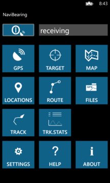
NaviBearing for Windows Phone
Tech Specs
- • Version: 2.6.1.0
- • Price: 0
- • Content Rating: Not Rated
- • Requirements: Windows Phone 8.1, Windows Phone 8
- • File Name: NaviBearing.XAP
User Ratings

- • Rating Average:
- 0 out of 5
- • Rating Users:
- 0
Download Count
- • Total Downloads:
- 4
- • Current Version Downloads:
- 4
- • Updated: September 9, 2016
More About NaviBearing
This application utilizes the device GPS receiver to retrieve location data, and Here Maps for visualization.
Serves distance estimation and route selection tactics in offroad orienteering and boat / yacht navigation, Find Your Car, geocaching, tracking Locations and travelled Paths.
Supports GPX data format for exporting / importing Locations (Waypoints), Routes and Tracks.
Supports Cloud storage (OneDrive account) for uploading / downloading GPX data files.
Use Cloud to store and share GPX data files between local storage, friends and other sources.
GPS Data
Realtime GPS data view (location, altitude, velocity, heading) and 'analog' compass with North-up / Heading-up views.
Locations (Waypoints, Favorites)
Define collections of Locations (name, coordinates). Export / import Locations (Waypoints) as GPX files. Create, export, import and share Location Sets as GPX files for different purposes.
Target tracker
Realtime GPS Heading and Velocity, Bearing, Distance and effective speed (VMG, Velocity Made Good) to the selected Target.
'Analog' compass (GPS Heading) with North-up / Heading-up views.
The secondary arrow indicator shows Bearing to the selected Target Location.
Automatically calculates the distances of Locations (from current coordinates / selected Location).
Routes
Define Your own Routes (collections of RoutePoints in numbered order).
Add, remove and reorder Route points for building the desired path.
Automatically calculates the bearings and distances between Route points.
Create, export, import and share Routes as GPX files for different purposes.
* Run the Route in Simulation mode. Select altitude, pitch and groundspeed in the map and fly over the route step by step. Hold on desired spot, explore the Map and continue.
* Run the Route in Route Guidance mode. With GPS receiving, the app sets the Route points in order as Targets, switching to the next point when one is reached.
You can start on desired Point and travel the Route in Forward or Reverse directions.
Live Map view
with zoom, tilt and rotation. Road, Terrain, Aerial and Hybrid map modes.
Map Tools:
-current Set of Locations and selected Route (Waypoints) can be visualized on Map.
-Tracks (path of movement) can be sampled and visualized on Map, and exported / imported as GPX data files.
-A Heading Extension line can be added to Moving Cursor to assist bearings to Map objects beyond visual range.
-currently selected Target can be visualized on Map (tag and bearing line from current location).
Tracks
Visualize Active and Reference Track paths on the Map.
Inspect sampled or GPX-imported Track data as values (start time, length, duration, avg speed, avg pace) and as graphs (velocity@time, altitude@distance). Compare Active track against other (Reference) tracks.
Local database for Target Location definitions.
Local database for Route definitions.
File Manager
Manage GPX data files in local storage and in Cloud (OneDrive account).
Upload / Download of GPX files.
Select formats / units of the value fields of the display pages with according buttons.
Coordinates: [DMS] [D.d] [DM.m]
Altitude: [ft] [m] [km]
Velocity: [m/s] [km/h] mph] [kts]
Distance: [ft] [yd] [m] [km] [mi] [nm]