Metar Weather Map 1.3.1.0 for Windows Phone
A Free News & Weather App
Published By Cybercom Poland Sp. z o.o.
METAR Weather Map is a connection of most current weather reports and maps. It provides information about above 4000 airports all over the world. It is an ... Read More > or Download Now >
Metar Weather Map for Windows Phone
Tech Specs
- • Version: 1.3.1.0
- • Price: 0
- • Content Rating: Not Rated
- • Requirements: Windows Phone 8.1, Windows Phone 8
- • File Name: Metar-Weather-Map.XAP
User Ratings

- • Rating Average:
- 4.4 out of 5
- • Rating Users:
- 641
Download Count
- • Total Downloads:
- 4
- • Current Version Downloads:
- 4
- • Updated: November 21, 2013
More About Metar Weather Map
It's created by Cybercom Poland for pilots, aviation passionate and people who need accurate weather information. We are a high-tech software consulting company located in Poland. We create software for connected world. Find out more at: http://www.cybercom.pl/
Features:
- Beautiful Live Tiles with weather of choosen airports (NEW!)
- Special page for Airport info (NEW!)
- High contrast mode (NEW!)
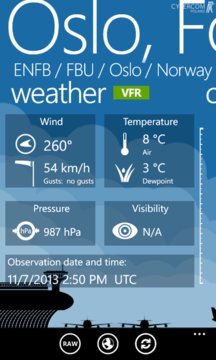
- Database provides above 4000 airports with details like location, elevation, type of airport, using radio frequencies, departures and arrivals;
- METARs, TAFs and NOTAMs
- Marking airports on a map with different colors and icons depending on the weather and type of airport
- CloudView to visualise cloud layers.
- METARs history
- Setting pages with fully customized to your preferences units
- Searching for airports by ICAO, IATA, City, Country or Name
- Dashboard with your favorite airports
- Nearby airports
- Ability to send raw METAR and TAF by SMS to friends
- Ruler mode allows you to measure straight distance between pinned pushpins
- Customizable flight's categories (VFR,MVFR,IFR,LIFR)
New in version 1.3 (XI.2013)
- New LiveTiles
- Redesigned User Experience and User Interface
- New special page for Airport Info
- New unit - distance
- Flight Categories added to METAR's history and Forecast
- New option: High Contrast Mode
- DateTime format depends on the phone settings
- Updated airport database
- Fixes on Map screen
- Fixes on Settings Screen
- Fixed redownloading Metars
- Fixed calculating of the SeaLevel pressure