DescriptionMarine Navigation / Charts App offers access to NOAA & USACE RNC nautical charts with POI data from ENC charts. The app also includes 7000+ ... Read More > or Download Now >
Marine Navigation for Windows Phone
Tech Specs
- • Version: 10.0.0.0
- • Price: 0
- • Content Rating: Not Rated
- • Requirements: Windows Phone 8.1, Windows Phone 8
- • File Name: Marine-Navigation.XAP
User Ratings

- • Rating Average:
- 3.5 out of 5
- • Rating Users:
- 27
Download Count
- • Total Downloads:
- 6
- • Current Version Downloads:
- 6
- • Updated: August 25, 2016
More About Marine Navigation
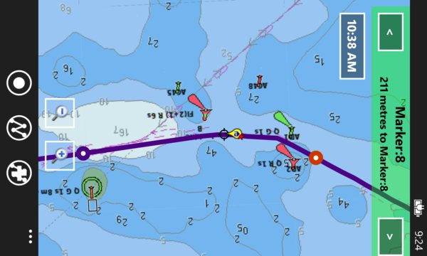
Marine Navigation / Charts App offers access to NOAA & USACE RNC nautical charts with POI data from ENC charts. The app also includes 7000+ freshwater lake maps. It supports Marine Charts course up orientation. Includes marine weather data (Tide & Currents data). It has route manager to create new boating routes or import existing GPX/KML routes.
Only marine navigation app to have route assistance with Voice Prompts for marine navigation.
* Voice Prompts for marine navigation / nautical naviagtion (requires GPS )
-prompts on approaching a boating route marker
-Continous distance and ETA updates
-Alerts when sailing/boating off route
-Alerts when boating in wrong direction
*Route Editing/Creation
-Create routes from scratch
-Edit GPX/KML routes.
-Add custom description to route points.
-Drop markers along route.
* Offline NOAA charts, USACE rivers, Lake Depth Maps(FreshWater Lakes)
-Visual / Text Search
-Chart Catalog
-Charts reprojected for WGS84 datum
* (NEW)FreshWater Lake maps:
- 7000+ lake depth charts
- Includes boat ramps data
- 1ft / 3ft depth contour maps for anglers for selected lake maps.
- Selected lake maps also contain fishing hot spots.
- Create custom fishing hot spots
* Tide & Currents
-High / Low tides.
-Tidal Currents.
-Active currents stations.
*Seamless chart quilting of marine charts
*Distance Bearing tool
*Create custom way points
- Using GPS
-Select point on map
-Manually enter latitude & longitude
*POI layer for marine charts
- Overlay POIs
- POIs derived from equivalent ENC and contains all categories including Buoy, Light, Harbour facility, Obstr.
*Search POIs/Way points
*Pan/Zoom/My Location
* Record Marine GPS tracks
* View tracks overlay
* Live track animation
* Track analytics/stats
* Export GPX trcks to SDCard
-Share GPX trakcs with friends/View on Google earth.
* Auto Follow Mode (Course up)
-Continuously updates boat's location on chart
- Adjustable update frequency