GPS Satellite provides the location and course data calculated from your phone's global positioning satellite (GPS) receive in conjunction with received ... Read More > or Download Now >
GPS Satellite for Windows Phone
Tech Specs
- • Version: 8.26.0.0
- • Price: 0
- • Content Rating: Not Rated
- • Requirements: Windows Phone 8.1, Windows Phone 8
- • File Name: GPS-Satellite.XAP
User Ratings

- • Rating Average:
- 4 out of 5
- • Rating Users:
- 29394
Download Count
- • Total Downloads:
- 212
- • Current Version Downloads:
- 103
- • Updated: April 25, 2018
More About GPS Satellite
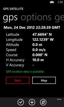
Data includes:
* latitude
*longitude
* altitude
* speed
* course
* horizontal accuracy
* vertical accuracy
* date and time
* 3 geocache sites
* multi-satellite dilution values and ratings, plus point source
GPS Satellite allows you to send the location(map link, latitude, longitude, and image) and tracking information to the following:
* SMS
* post to your favorite social network like Twitter
* clipboard to pasted into other applications
For Windows 10 desktop, you can now save and load position data points. This will come to Windows 10 mobile after some testing by customers.
View the nice guide page explaining all features!
Coordinates can be displayed with:
* decimal degrees
* decimal degrees with direction
* degrees and minutes
* degrees, minutes, and seconds
Mapping allows you the following view:
* road
* aerial
* hybrid
* terrain
* pitch control
* pedestrian and landmark features
Speeds can be displayed wit the following formats:
* miles per second
* miles per hour
* kilometers per hour
* knots
* feet per second
Latitude and longitude can be displayed in a LARGE nicely formatted screen.
Tasks can be performed on the tasks page.
NASA photo of the day provided.
Holding your finger on the map page for a second, you will get the latitude and longitude of that position in addition to the other data.
Privacy policy: Upon your actions, this application accesses your location to display and can, of your choice, save the location to a file. You may also load the file or share the location.
Compass location traffic.