Use any photo as a map!MapSnap GPS is a fast and easy handheld map for those situations where road maps aren't good enough and you can't download a map.Just ... Read More > or Download Now >
Mapsnap GPS for Windows Phone
Tech Specs
- • Version: 2.44.0.0
- • Price: 0
- • Content Rating: Not Rated
- • Requirements: Windows Phone 8.1
- • File Name: Mapsnap-GPS.XAP
User Ratings

- • Rating Average:
- 4.6 out of 5
- • Rating Users:
- 54
Download Count
- • Total Downloads:
- 30
- • Current Version Downloads:
- 30
- • Updated: October 6, 2016
More About Mapsnap GPS
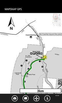
MapSnap GPS is a fast and easy handheld map for those situations where road maps aren't good enough and you can't download a map.
Just take a photo of a paper map using the camera in your device, mark your location using your inbuilt GPS, select the scale (or mark another location), and you're good to go.
Whether you're hiking, trekking, cycling, or just sick of endlessly unfolding and refolding tourist or amusement park maps, MapSnap GPS is the perfect tool!
MapSnap GPS
• Allows you to photograph a physical map or use any image as a moving map
• Shows your current GPS map position in real time
• Adds a dynamic scale indicator (kilometres or miles) and a north indicator to every map
• Can rotate maps to north, to your current bearing, or to true north (using the compass)
• Supports OneDrive/email/phone GPX path export for upload to sites like Google or Bing maps
• Can load GPX files as "guide" routes
• Has a realtime GPS dashboard
• Can run under a locked screen
• Automatically saves "snapped" maps and calibration data for every map you've used
• Supports latitude/longitude, UTM/UPS, and MGRS georeferencing
• Doesn't require a data connection for navigation - all maps are stored offline
• Has a deep zoom function, perfect for fine details in scanned maps
• Is great for trailhead maps and corn mazes!
Your personal details and location will never be shared, disclosed, or transmitted outside your phone, except when you export GPX track logs to OneDrive or email